
Monitoring Land Use and Land Cover Change in Eastern Nepal: a Remote Sensing Perspective on the Dudh Koshi River Watershed (2000–2020)
Published 2026-06-29
Keywords
- Land Use and Land Cover (LULC) Change,
- Dudh Koshi Watershed,
- Remote Sensing and GIS,
- Climate Change Adaptation,
- Participatory Governance
How to Cite
Copyright (c) 2026 Bibash Dhakal, Nirvay Guragai, Shobharam KC, Ciro Apollonio, Andrea Petroselli

This work is licensed under a Creative Commons Attribution 4.0 International License.


Abstract
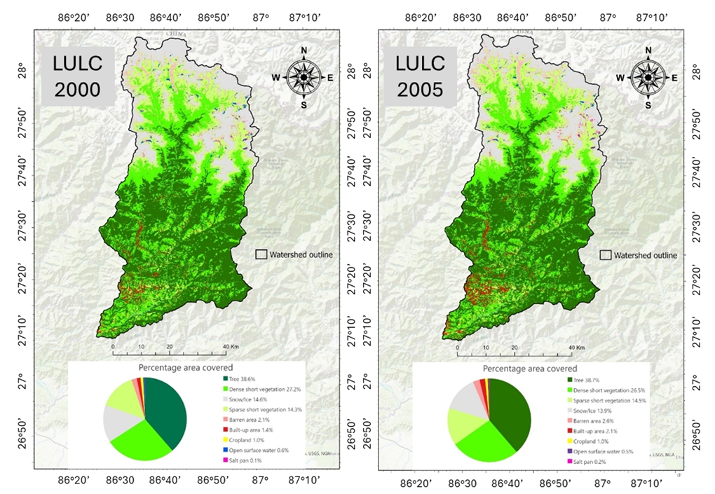
This study analyzes two decades (2000–2020) of Land Use and Land Cover (LULC) change in the Dudh Koshi River watershed, eastern Nepal—a climatically sensitive and topographically complex Himalayan region. Using multi-temporal satellite imagery and GIS-based analysis across eight sub-basins, we quantified changes in forest, rangeland, snow, bare ground, cropland, built-up areas, and water bodies. Key trends include glacial retreat (–0.9%), rangeland degradation (–2.4%), and a tripling of built-up land (+2.6%). Spatial patterns reflect elevation, road access, and proximity to settlements, while drivers include climate change, rural depopulation, and infrastructure expansion. These dynamics affect ecosystem services, water security, and rural livelihoods. Our findings underscore the need for integrated, community-engaged watershed management and call for future research using high-resolution data and socio-ecological frameworks to inform climate-resilient development in fragile mountain systems.
References
- Al-Adamat, R., Alayyash, S., Al-Amoush, H., Al-Meshan, O., Rawajfih, Z., Shdeifat, A., Al-harahsheh, A., Alfarajat, M. (2012). The Combination of Indigenous Knowledge and Geo-Informatics for Water Harvesting Siting in the Jordanian Badia. Journal of Geographic Information System, 4, 366-376. 10.4236/jgis.2012.44042.
- Apollonio, C., Iemmolo, G., Di Modugno, M., Apollonio, M., Petroselli, A., Recanatesi, F., & Giannetta, D. (2025). A Multi-Parameter Approach to Support Sustainable Hydraulic Risk Analysis for the Protection of Transportation Infrastructure: The Case Study of the Gargano Railways (Southern Italy). Sustainability (Switzerland), 17(9), 1–24. https://doi.org/10.3390/su17094151
- Aryal, K., Cockfield, G., & Maraseni, T. N. (2019). Perceived changes in land use and ecosystem services in the Koshi river basin, Nepal. Environmental Development, 29, 100515.
- Asian Development Bank. (2016). Managing Nepal’s Dudh Koshi River System for a Fair and Sustainable Future. Manila: Asian Development Bank.
- Bajracharya, S. R., Maharjan, S. B., & Shrestha, F. (2018). The status and decadal change of glaciers in the Koshi Basin, Central Himalaya, Nepal. Mountain Research and Development.
- Basnet, B. (2015). Community forestry in Nepal: A paradigm shift in forest management. Journal of Forest and Livelihood.
- Chen, J., Wang, Y., Wang, J., Zhang, Y., Xu, Y., Yang, O., Zhang, R., Wang, J., Wang, Z., Lu, F., & Hu, Z. (2024). The Performance of Landsat-8 and Landsat-9 Data for Water Body Extraction Based on Various Water Indices: A Comparative Analysis. Remote Sensing, 16(11). https://doi.org/10.3390/rs16111984
- DCRL. (2020). Land Use 2019 Map Lower Dudhkoshi Watershed. Kathmandu: Department of Forest Research and Survey.
- FAO. (2023). Land use, land cover and soil sciences. Rome: Food and Agriculture Organization of the United Nations.
- Farr, T. G., Rosen, P. A., Caro, E., Crippen, R., Duren, R., Hensley, S., ... & Alsdorf, D. (2007). The Shuttle Radar Topography Mission. Reviews of Geophysics.
- Forzini, E., Piemontese, L., Bresci, E., ... Pun, S., Castelli, G. (2022) Identification of suitable sites for traditional pokhari water harvesting in mountain rural communities of the Himalaya. Hydrology Research, 53(11), 1340–1356
- FRTC. (2022). National Land Cover Monitoring System of Nepal. Forest Research and Training Centre (FRTC). Kathmandu, Nepal. https://frtc.gov.np/uploads/files/Study Report Inner-final.pdf
- Garrard, R., Kohler, T., Price, M. F., Byers, A. C., Sherpa, A. R., & Maharjan, G. R. (2016). Land Use and Land Cover Change in Sagarmatha National Park, a World Heritage Site in the Himalayas of Eastern Nepal. Mountain Research and Development, 36(3), 299–310. https://doi.org/10.1659/MRD-JOURNAL-D-15-00005.1
- Government of Nepal. (2015). National Land Use Policy 2015. Kathmandu: Ministry of Land Reform and Management.
- Hanif, F., Kanae, S., Farooq, R., Iqbal, M. R., & Petroselli, A. (2023). Impact of Satellite-Derived Land Cover Resolution Using Machine Learning and Hydrological Simulations. Remote Sensing, 15(22). https://doi.org/10.3390/rs15225338
- Humagain, Y., & Garrard, R. (2020). Land use/land cover change in the Dudhkoshi River Basin, Sagarmatha National Park, Nepal. Open Journal of Ecology.
- ICIMOD. (2010). Land use/cover map for the Dudh Koshi River Basin. Kathmandu: International Centre for Integrated Mountain Development.
- ICIMOD. (2013). Koshi Basin Programme: Annual report 2013. Kathmandu: International Centre for Integrated Mountain Development.
- Khadka, M. (2017). Glacio-Hydrological Modelling of Dudh Koshi River Basin , Nepal. 1–40.
- Kumar, P., & Hole, F. (2021). Land use/land cover change and its implication on soil erosion in an Indian Himalayan watershed.
- Lillesø, J. P. B., Shrestha, T. B., Dhakal, L. P., Nayaju, R. P., & Shrestha, R. (2005). Vegetation types and altitudinal shifts in Nepal. Kathmandu: Forest and Landscape Development and Environment Series.
- Młyński D., Wojkowski J., Wałęga A., Lepeška T., Petroselli A., R.-P. A. (2025). Transformations in hydrological resilience: unraveling the impact of Landscape Hydric Potential on flood dynamics: a case study, Drwinka catchment (Poland).
- Nie, Y., Pritchard, H. D., Liu, Q., Hennig, T., Wang, W., Wang, X., Liu, S., Nepal, S., Samyn, D., Hewitt, K., & Chen, X. (2021). Glacial change and hydrological implications in the Himalaya and Karakoram. Nature Reviews Earth and Environment, 2(2), 91–106. https://doi.org/10.1038/s43017-020-00124-w
- Novelli, A., Tarantino, E., Caradonna, G., Apollonio, C., Balacco, G., Piccinni, F. (2016). Improving the ANN Classification Accuracy of Landsat Data Through Spectral Indices and Linear Transformations (PCA and TCT) Aimed at LU/LC Monitoring of a River Basin.
- Omali, T. U. (2018). Impacts of Sensor Spatial Resolution on Remote Sensing Image Classification.
- Paudel, B., Tamang, S., & Shrestha, K. K. (2021). Drivers of land use and land cover change in the Koshi River Basin of Nepal. Environmental Management.
- Pelorosso, R., Apollonio, C., Rocchini, D., & Petroselli, A. (2021). Effects of land use-land cover thematic resolution on environmental evaluations. Remote Sensing, 13(7). https://doi.org/10.3390/rs13071232
- Petroselli, A. (2012). LIDAR data and hydrological applications at the basin scale. GIScience and Remote Sensing, 49(1), 139–162. https://doi.org/10.2747/1548-1603.49.1.139
- Pokhrel, R. P., & Kamar, M. (2023). Driving Factors behind the Land Use Land Cover Change in Hilly Region in Gorkha Municipality, Nepal. The Himalayan Geographers, 13, 34–44. https://doi.org/10.3126/thg.v13i1.71344
- Ranaparkhi, N. S. (2019). Image Mosaic. 7(1), 1–17.
- Rasool, R., Fayaz, A., Shafiq, M. ul, Singh, H., & Ahmed, P. (2021). Land use land cover change in Kashmir Himalaya: Linking remote sensing with an indicator based DPSIR approach. Ecological Indicators, 125(February), 107447. https://doi.org/10.1016/j.ecolind.2021.107447
- Rawat, A. S., & Sah, R. (2009). Traditional knowledge of water management in Kumaon Himalaya. Indian Journal of Traditional Knowledge, 8(2), 249–254.
- Recanatesi F., P. A. (2020). Land Cover Change and flood risk in a peri-urban environment of the Metropolitan area of Rome (Italy).
- Sharma, S., Mahajan, A.K. (2020) GIS-based sub-watershed prioritization through morphometric analysis in the outer Himalayan region of India. Appl Water Sci 10, 163.
- Shrestha, S., Nepal, S., & Pandey, V. P. (2015). Assessment of land cover change and its impact on ecosystem services in the Koshi River Basin, Nepal. Environmental Monitoring and Assessment.
- Tejaswini V., S. K. K. (2025). Comparison of digital elevation models for hydrological modeling. International Journal of Agricultural Sciences.
- Umukiza E., Raude J.M., Petroselli A., Wandera S.M., Gathenya J.M., A. C. (2022). Drainage systems design in urbanized areas under land use changes scenarios: case study of Narok Town (Kenya).
- UNDP. (2024). Developing Climate Resilient Livelihoods in the Vulnerable Watershed of Nepal.
- Zurayk, R., El-Awar, F., Hamadeh, S., ... Chehab, A.-G., Shab, K.A. (2001). Using indigenous knowledge in land use investigations: A participatory study in a semi-arid mountainous region of Lebanon. Agriculture Ecosystems and Environment, 86(3), 247–262