
GIS-Fuzzy Logic Approach for Ecological Restoration Suitability Mapping in Semi-Arid Steppe Ecosystems: A Case Study of Naâma Province, Algeria
Published 2026-06-29
Keywords
- Ecological restoration,
- fuzzy membership functions,
- restoration prioritization,
- semi-arid land degradation,
- steppe landscapes
- spatial modeling ...More
How to Cite
Copyright (c) 2026 Abderrahmane Mebarki, Tayeb Sitayeb

This work is licensed under a Creative Commons Attribution 4.0 International License.


Abstract
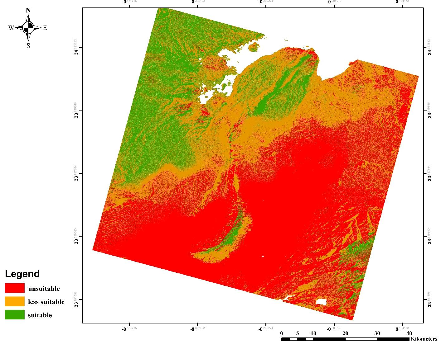
This research evaluates the ecological restoration suitability in the northeastern region of Naâma Province, Algeria, a fragile environment undergoing increasing degradation from both climatic stresses and human activities. The study area, including the municipalities of El Biodh and Mecheria, is located in a semi-arid steppe zone, known for its biodiversity and restoration potential. The objective of this study is to produce a spatially explicit map of restoration suitability by integrating fuzzy logic, GIS-based multi-criteria analysis, and environmental variables. A total of 20 indicators (topographic, pedological, climatic, and vegetative) were normalized and combined using fuzzy membership functions. The fuzzy overlay was followed by a defuzzification step using the centroid method to produce a composite suitability map, which was categorized into three classes: suitable, less suitable, and unsuitable. The results showed a heterogeneous spatial distribution, with 47.65% of the landscape classified as unsuitable, 36.08% as less suitable, and only 16.27% as suitable. For model validation, 300 random points were generated, and multiple linear regression was applied to evaluate the influence of each variable group. Climatic variables showed the strongest correlation with suitability (R = 0.924, p < 0.001), followed by proximity factors (R = 0.719, p < 0.005), topography (R = 0.647, p < 0.001), soil properties (R = 0.521, p < 0.001), and vegetation indices (R = 0.337, p < 0.001). The study confirms the effectiveness of combining fuzzy logic and GIS for ecological restoration planning and highlights priority areas for intervention within arid and semi-arid landscapes.
References
- Abdellaoui, A., & Marmi, R. (2010). Mise en evidence de mouvements de sable à partir d’images satellitales; application au piemont sud de l’atlas saharien (Algerie). Ann Univ Bucharest: Geography Series, 10.
- Abdellaoui, A., & Rougab, A. (1997). Caractérisation de la réponse du bâti: application au complexe urbain de Blida (Algérie). Universités francophones. Actualité scientifique, 75-83.
- Aguirre-Salado, C. A., Miranda-Aragón, L., Pompa-García, M., Reyes-Hernández, H., Soubervielle-Montalvo, C., Flores-Cano, J. A., & Méndez-Cortés, H. (2017). Improving identification of areas for ecological restoration for conservation by integrating USLE and MCDA in a GIS-environment: A pilot study in a priority region Northern Mexico. ISPRS International Journal of Geo-Information, 6(9), 262. https://doi.org/10.3390/ijgi6090262
- Aidoud, A., Le Floc’h, E., & Le Houérou, H. N. (2006). Les steppes arides du nord de l’Afrique. Sécheresse, 17(1–2), 19–30.
- Allbed, A., Kumar, L., & Aldakheel, Y. Y. (2014). Assessing soil salinity using soil salinity and vegetation indices derived from IKONOS high-spatial resolution imageries: Applications in a date palm dominated region. Geoderma, 230, 1-8. https://doi.org/10.1016/j.geoderma.2014.03.025
- Allen, R. G., Pereira, L. S., Raes, D., & Smith, M. (1998). Crop evapotranspiration-Guidelines for computing crop water requirements. FAO Irrigation and drainage paper 56. FAO, Rome, 300(9), D05109.
- Amami, R., Ibrahimi, K., Sher, F., Milham, P., Ghazouani, H., Chehaibi, S., ... & Iqbal, H.M. (2021). Impacts of different tillage practices on soil water infiltration for sustainable agriculture. Sustainability, 13(6), 3155. https://doi.org/10.3390/su13063155
- Aronson, J., Milton, S. J., & Blignaut, J. N. (2006). Restoring natural capital. Scientist (Philadelphia, Pa.), 20.
- Millennium Ecosystem Assessment (2005). Ecosystems and human well-being: our human planet-summary for decision-makers. Island Press, Washington DC, USA.
- Barry, R. G., & Chorley, R. J. (2009). Atmosfera, tempo e clima. Bookman Editora.
- Batjes, N. H. (1996). Total carbon and nitrogen in the soils of the world. European journal of soil science, 47(2), 151-163. https://doi.org/10.1111/j.1365-2389.1996.tb01386.x
- Batjes, N. H. (2011). Soil organic carbon stocks under native vegetation–Revised estimates for use with the simple assessment option of the Carbon Benefits Project system. Agriculture, Ecosystems and Environment, 142(3-4), 365-373. https://doi.org/10.1016/j.agee.2011.06.007
- Beven, K. J., & Kirkby, M. J. (1979). A physically based, variable contributing area model of basin hydrology/Un modèle à base physique de zone d'appel variable de l'hydrologie du bassin versant. Hydrological sciences journal, 24(1), 43-69. https://doi.org/10.1080/02626667909491834
- Bortoleto, L. A., Figueira, C. J. M., Dunning Jr, J. B., Rodgers, J., & Da Silva, A. M. (2016). Suitability index for restoration in landscapes: An alternative proposal for restoration projects. Ecological Indicators, 60, 724-735. https://doi.org/10.1016/j.ecolind.2015.08.002
- Brady, N. C., & Weil, R. R. (2016). The Nature and Properties of Soils. 15th edition, New York., USA
- Ceccato, P., Gobron, N., Flasse, S., Pinty, B., & Tarantola, S. (2002). Designing a spectral index to estimate vegetation water content from remote sensing data: Part 1: Theoretical approach. Remote sensing of environment, 82(2-3), 188-197. https://doi.org/10.1016/S0034-4257(02)00037-8
- Chen, D., Huang, J., & Jackson, T. J. (2005). Vegetation water content estimation for corn and soybeans using spectral indices derived from MODIS near-and short-wave infrared bands. Remote Sensing of Environment, 98(2-3), 225-236. https://doi.org/10.1016/j.rse.2005.07.008
- Conrad, O., Bechtel, B., Bock, M., Dietrich, H., Fischer, E., Gerlitz, L., ... & Böhner, J. (2015). System for automated geoscientific analyses (SAGA) v. 2.1. 4. Geoscientific model development, 8(7), 1991-2007. https://doi.org/10.5194/gmd-8-1991-2015
- El-Gammal, M. I., Ali, R. R., & Samra, R. A. (2014). NDVI threshold classification for detecting vegetation cover in Damietta governorate, Egypt. Journal of American Science, 10(8), 108-113.
- Estoque, R. C., & Murayama, Y. (2017). A worldwide country-based assessment of social-ecological status (c. 2010) using the social-ecological status index. Ecological Indicators, 72, 605-614. https://doi.org/10.1016/j.ecolind.2016.08.047
- Fageria, N. K., & Barbosa Filho, M. P. (2008). Influence of pH on productivity, nutrient use efficiency by dry bean, and soil phosphorus availability in a no‐tillage system. Communications in Soil Science and Plant Analysis, 39(7-8), 1016-1025. https://doi.org/10.1080/00103620801925422
- FAO. (2006). Guidelines for soil description (4th ed.). Food and Agriculture Organization, Rome, Italy.
- Fick, S. E., & Hijmans, R. J. (2017). WorldClim 2: new 1‐km spatial resolution climate surfaces for global land areas. International journal of climatology, 37(12), 4302-4315. https://doi.org/10.1002/joc.5086
- Fisher, R. A., Koven, C. D., Anderegg, W. R., Christoffersen, B. O., Dietze, M. C., Farrior, C. E., ... & Moorcroft, P. R. (2018). Vegetation demographics in Earth System Models: A review of progress and priorities. Global change biology, 24(1), 35-54. https://doi.org/10.1111/gcb.13910
- Forman, R. T., & Alexander, L. E. (1998). Roads and their major ecological effects. Annual review of ecology and systematics, 29(1), 207-231. https://doi.org/10.1146/annurev.ecolsys.29.1.207
- Gesch, D., Oimoen, M., Greenlee, S., Nelson, C., Steuck, M., & Tyler, D. (2002). The national elevation dataset. Photogrammetric engineering and remote sensing, 68(1), 5-32.
- Greco, J. (1966). L’érosion, la défense et la restauration des sols. Le reboisement en Algérie. M.A.R.A., Alger.
- Hengl, T., Mendes de Jesus, J., Heuvelink, G. B., Ruiperez Gonzalez, M., Kilibarda, M., Blagotić, A., ... & Kempen, B. (2017). SoilGrids250m: Global gridded soil information based on machine learning. PLoS one, 12(2), e0169748. https://doi.org/10.1371/journal.pone.0169748
- Hijmans, R. J., Cameron, S. E., Parra, J. L., Jones, P. G., & Jarvis, A. (2005). Very high-resolution interpolated climate surfaces for global land areas. International Journal of Climatology: A Journal of the Royal Meteorological Society, 25(15), 1965-1978. https://doi.org/10.1002/joc.1276
- Hillel, D. (2003). Introduction to environmental soil physics. Elsevier.
- Hirche, A., Salamani, M., Abdelmadjid, B., Nedjraoui, D., Hourizi, R., Oukil, Y., ... & Grandi, M. (2015). Thirty years of ecological monitoring in Algerian arid rangelands. Environmental Research Journal, 9(3).
- Huang, T., Pang, Z., & Edmunds, W. M. (2013). Soil profile evolution following land‐use change: Implications for groundwater quantity and quality. Hydrological Processes, 27(8), 1238-1252. https://doi.org/10.1002/hyp.9302
- Huete, A. R. (1988). A soil-adjusted vegetation index (SAVI). Remote sensing of environment, 25(3), 295-309. https://doi.org/10.1016/0034-4257(88)90106-X
- Hutchinson, M. F., & Xu, T. (2004). ANUSPLIN version 4.4 user guide. Centre for Resource and Environmental Studies, The Australian National University, Canberra, 54.
- HydroSHEDS. (2023). Hydrological data and maps based on SHuttle Elevation Derivatives. https://www.hydrosheds.org/
- IPCC, I. P. O. C. C. (2006). THE IPCC. Guidelines for national greenhouse gas inventories, prepared by the national green-house gas inventories programme. Prepared by the National Greenhouse Gas Inventories Programme. Eggleston, H.S., Buendia, L, Miwa, K., Ngara, T., Tanabe, K. (eds). IGES, Japan.
- Jenks, G. F. (1967). The data model concept in statistical mapping. International yearbook of cartography, 7, 186-190.
- Jenness, J. (2006). Topographic Position Index (tpi_jen. avx) extension for ArcView 3. x, v. 1.3 a. Jenness Enterprises.
- Kharroubi, M., Bouselsal, B., Ouarekh, M., Benaabidate, L., & Khadri, R. (2022). Water quality assessment and hydrogeochemical characterization of the Ouargla complex terminal aquifer (Algerian Sahara). Arabian Journal of Geosciences, 15(3), 251. https://doi.org/10.1007/s12517-022-09438-z
- Konukcu, F., Gowing, J. W., & Rose, D. A. (2006). Dry drainage: A sustainable solution to waterlogging and salinity problems in irrigation areas?. Agricultural water management, 83(1-2), 1-12. https://doi.org/10.1016/j.agwat.2005.09.003
- Köppen, R. (1936). Kristallisationsvorgänge in Kaliumchloridlösungen. Zeitschrift für anorganische und allgemeine Chemie, 228(2), 169-174.
- Körner, C. (2007). The use of ‘altitude’ in ecological research. Trends in ecology and evolution, 22(11), 569-574. https://doi.org/10.1016/j.tree.2007.09.006
- Kumar Ra, P., Nathawat, M. S., & Onagh, M. (2014). Application of multiple linear regression model through GIS and remote sensing for malaria mapping in Varanasi District, INDIA. Health Science Journal.
- Lal, R. (2004). Soil carbon sequestration impacts on global climate change and food security. Science, 304(5677), 1623-1627. https://doi.org/10.1126/science.1097396
- Lamb, D., Erskine, P. D., & Parrotta, J. A. (2005). Restoration of degraded tropical forest landscapes. Science, 310(5754), 1628-1632. https://doi.org/10.1126/science.1111773
- Le Houérou, H. N. (1995). Climate change, drought and desertification. Journal of Arid Environments, 30(4), 313–332. https://doi.org/10.1006/jare.1996.0099
- Leempoel, K., Parisod, C., Geiser, C., Daprà, L., Vittoz, P., & Joost, S. (2015). Very high‐resolution digital elevation models: are multi‐scale derived variables ecologically relevant? Methods in Ecology and Evolution, 6(12), 1373-1383. https://doi.org/10.1111/2041-210X.12427
- Lehner, B., Verdin, K., & Jarvis, A. (2008). New global hydrography derived from spaceborne elevation data. Eos, Transactions American Geophysical Union, 89(10), 93-94. https://doi.org/10.1029/2008EO100001
- Majeed, S. M. (2010). Cluster detection and analysis with geo-spatial datasets using a hybrid statistical and neural networks hierarchical approach. University of South Wales, UK.
- Malczewski, J. (2006). GIS‐based multicriteria decision analysis: a survey of the literature. International journal of geographical information science, 20(7), 703-726. https://doi.org/10.1080/13658810600661508
- Mamdani, E. H., & Assilian, S. (1975). An experiment in linguistic synthesis with a fuzzy logic controller. International journal of man-machine studies, 7(1), 1-13.
- McCune, B., & Keon, D. (2002). Equations for potential annual direct incident radiation and heat load. Journal of vegetation science, 13(4), 603-606. https://doi.org/10.1111/j.1654-1103.2002.tb02087.x
- McKenzie, N. N., Jacquier, D. D., Isbell, R. R., & Brown, K. K. (2004). Australian soils and landscapes: an illustrated compendium. CSIRO publishing.
- Moore, I. D., Gessler, P. E., Nielsen, G. A. E., & Peterson, G. A. (1993). Soil attribute prediction using terrain analysis. Soil science society of america journal, 57(2), 443-452. https://doi.org/10.2136/sssaj1993.03615995005700020026x
- Nguyen, K. A., Liou, Y. A., Tran, H. P., Hoang, P. P., & Nguyen, T. H. (2020). Soil salinity assessment by using near-infrared channel and Vegetation Soil Salinity Index derived from Landsat 8 OLI data: a case study in the Tra Vinh Province, Mekong Delta, Vietnam. Progress in Earth and Planetary Science, 7(1), 1-16. https://doi.org/10.1186/s40645-019-0311-0
- Oke, T. R. (2002). Boundary layer climates. Routledge,UK.
- OpenStreetMap Contributors. (2023). BBBike Extract Service. https://extract.bbbike.org/
- Orta-Salazar, C., Aguirre-Salado, C. A., Reyes-Hernández, H., Reyes-Agüero, J. A., & Muñoz-Robles, C. A. (2021). Mapping Potential Areas for Conservation Under Forest Carbon Credit Eligibility in a Natural Protected Area in Northern Mexico. Tropical Conservation Science, 14, 19400829211029448. https://doi.org/10.1177/19400829211029448
- Ostovari, Y., Moosavi, A. A., & Pourghasemi, H. R. (2020). Soil loss tolerance in calcareous soils of a semiarid region: evaluation, prediction, and influential parameters. Land Degradation and Development, 31(15), 2156-2167. https://doi.org/10.1002/ldr.3597
- Pontius, R. G., Thontteh, O., & Chen, H. (2008). Components of information for multiple resolution comparison between maps that share a real variable. Environmental and ecological statistics, 15, 111-142. https://doi.org/10.1007/s10651-007-0043-y
- Post, W. M., & Kwon, K. C. (2000). Soil carbon sequestration and land‐use change: processes and potential. Global change biology, 6(3), 317-327. https://doi.org/10.1046/j.1365-2486.2000.00308.x
- Primer, S. E. R. I. (2004). Society for Ecological Restoration International. Science and Policy Working Group the SER International Primer on Ecological Restoration. Soc. Ecol. Restor. Int.
- Questad, E. J., Kellner, J. R., Kinney, K., Cordell, S., Asner, G. P., Thaxton, J., ... & Tucker, B. (2014). Mapping habitat suitability for at‐risk plant species and its implications for restoration and reintroduction. Ecological Applications, 24(2), 385-395. https://doi.org/10.1890/13-0775.1
- Quézel, P., & Médail, F. (2003). Ecology and biogeography of Mediterranean ecosystems in North Africa. Springer.
- Rahmati, O., Haghizadeh, A., Pourghasemi, H. R., & Noormohamadi, F. (2016). Gully erosion susceptibility mapping: the role of GIS-based bivariate statistical models and their comparison. Natural hazards, 82, 1231-1258. https://doi.org/10.1007/s11069-016-2239-7
- Rengasamy, P., Chittleborough, D., & Helyar, K. (2003). Root-zone constraints and plant-based solutions for dryland salinity. Plant and Soil, 257, 249-260. https://doi.org/10.1023/A:1027326424022
- Rouse Jr, J. W., Haas, R. H., Deering, D. W., Schell, J. A., & Harlan, J. C. (1974). Monitoring the vernal advancement and retrogradation (green wave effect) of natural vegetation (No. E75-10354).
- Sørensen, R., Zinko, U., & Seibert, J. (2005). On the calculation of the topographic wetness index: evaluation of different methods based on field observations. Hydrology and Earth System Sciences Discussions, 2(4), 1807-1834. https://doi.org/10.5194/hess-10-101-2006
- Xie, Y., Li, L., Wang, H., & Zhao, X. (2010, June). The application of threshold methods for image segmentation in oasis vegetation extraction. In 2010 18th International Conference on Geoinformatics (pp. 1-4). IEEE.
- Yang, J., Zhang, J., Wang, Z., Zhu, Q., & Liu, L. (2003). Activities of enzymes involved in sucrose-to-starch metabolism in rice grains subjected to water stress during filling. Field Crops Research, 81(1), 69-81. https://doi.org/10.1016/S0378-4290(02)00214-9
- Zadeh, L. A. (1965). Fuzzy sets. Information and control, 8(3), 338-353.
- Zadeh, L. A. (1973). Outline of a new approach to the analysis of complex systems and decision processes. IEEE Transactions on systems, Man, and Cybernetics, (1), 28-44.
- Zair, M. (2011). Bilan écologique et socio-économique des reboisements dans la wilaya de Naâma et perspectives d’avenir. Master thesis, Université Abou Bakr Belkaïd, Tlemcen, Algeria. Available at: https://dspace.univ-tlemcen.dz/bitstreams/e52775d9-c66e-4442-a88e-826556a09707/download
- Zomer, R. J., Trabucco, A., Bossio, D. A., & Verchot, L. V. (2008). Climate change mitigation: A spatial analysis of global land suitability for clean development mechanism afforestation and reforestation. Agriculture, ecosystems and environment, 126(1-2), 67-80. https://doi.org/10.1016/j.agee.2008.01.014