
Agricultural crop pattern mapping and change analysis at a sub-district level in South-eastern region, Bangladesh using Landsat satellite data from 2010 to 2019
Published 2022-12-26
Keywords
- agricultural crop mapping,
- winter season,
- remote sensing,
- Landsat satellite,
- South-eastern region
- Bangladesh ...More
How to Cite


Abstract
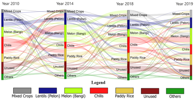
The study first time identified and analyzed winter season agricultural crop patterns (ACP) derived from Land use (LU) maps in between 2010 to 2019 of south-eastern regions of Chittagong, Bangladesh. ACP identification was a challenging task in the worldwide research relevant to crop-related studies. To overcome this, we have considered frequently used traditional unsupervised classifier, such as K-means clustering algorithm technique. This has been applied on 30m pixel Landsat satellite reflectance images to identify crop pattern of the study area using the ENVI 5.3 and ArcGIS 10.8 software’s, respectively. Multiple crops with seven classes were identified with the validation of in-situ ground-truth data and Google Earth (GE) images. The overall accuracy and kappa coefficient values were found at 81.96% and 0.79, respectively. The results suggest a significant variation of crop patterns in the study area and in recent time, the area largely dependent on mixed irrigation approach. Moreover, the crop pattern change was observed in the studied period as mixed crop 19% (9282.17 ha), Lentils (Pelon) 24.80% (11594.38 ha), Melon (Bangi) 22.37% (10461.08 ha), Chilis 17.90% (8367.48 ha), Paddy rice, unused land, and other crops, respectively. Among them, Lentils (Pelon) and Melon (Bangi) are identified as two common crops followed by mixed crops category, cultivated in the winter season as it required less irrigation compared to paddy rice area
References
- Atzberger, C., (2013). Advances in remote sensing of agriculture: context description, existing operational monitoring systems and major information needs. Remote Sensing 5(2), 949-981. DOI: https://doi.org/10.3390/rs5020949
- Belgiu, M., & Csillik, O., (2018). Sentinel-2 cropland mapping using pixel-based and object-based time-weighted dynamic time warping analysis. Remote Sensing of the Environment, 204, 509–523. https://doi.org/10.1016/j.rse.2017.10.005 DOI: https://doi.org/10.1016/j.rse.2017.10.005
- Bhuiyan, M.M.H., Islam, K., Islam, K.N., & Jashimuddin, M., (2019). Monitoring dynamic land-use change in rural–urban transition: a case study from Hathazari Upazila, Bangladesh. Geology, Ecology, and Landscapes, 3(4), 247-257. https://doi.org/10.1080/24749508.2018.1556034 DOI: https://doi.org/10.1080/24749508.2018.1556034
- Brammer, H., (1996). The geography of the Soils of Bangladesh. University Press Limited, Dhaka, Bangladesh
- Casasnovas, J.M., Montero, A.M., & Casterad, M.A., (2005). Mapping multi-year cropping patterns in small irrigation districts from timeseries analysis of Landsat TM images. European Journal of Agronomy, 23(2), 159-169. DOI: https://doi.org/10.1016/j.eja.2004.11.004
- Congalton, R.G., (1991). A review of assessing the accuracy of classifications of remotely sensed data. Remote Sensing of the Environment, 37, 35-46. DOI: https://doi.org/10.1016/0034-4257(91)90048-B
- Congalton, R.G., & Green, K., (2008). Assessing the Accuracy of Remotely Sensed Data: Principles and Practices, 2nd Ed. CRC Press. DOI: https://doi.org/10.1201/9781420055139
- Conrad, C., Fritch, S., Zeidler, J., Rücker, G., & Dech, S., (2010). Per-field irrigated crop classification in arid Central Asia using SPOT and ASTER data. Remote Sensing, 2(4),1035-1056. DOI: https://doi.org/10.3390/rs2041035
- Cohen, J., (1960). A coefficient of agreement of nominal scales. Educational and Psychological Measurements, 20(1), 37-46. DOI: https://doi.org/10.1177/001316446002000104
- Cuba, N., (2015). Research note: Sankey diagrams for visualizing land cover dynamics. Landscape and Urban Planning 139, 163-167. DOI: https://doi.org/10.1016/j.landurbplan.2015.03.010
- Garcia, A.S., De F.N. Vilela, V.M., Rizzo, R., West, P., Gerber, J.S., Engstrom, P.M., & Ballester, MV.R., (2019). Assessing land use/cover dynamics and exploring drivers in the Amazon's arc of deforestation through a hierarchical, multi-scale and multi-temporal classification approach. Remote Sensing Applications: Society and Environment, 15, 100233. https://doi.org/10.1016/j.rsase.2019.05.002 DOI: https://doi.org/10.1016/j.rsase.2019.05.002
- Feng, S., Zhao, J., Liu, T., Zhang, H., Zhang, Z., & Guo, X., (2019). Crop type identification and mapping using machine learning algorithms and Sentinel-2 time series data. IEEE Journal of Selected Topics in Applied Earth Observations and Remote Sensing, 12(9), 3295–3306. DOI: https://doi.org/10.1109/JSTARS.2019.2922469
- Foley, J.A., Ramankutty, N., Brauman, K.A., Cassidy, E.S., Gerber, J.S., Johnston, M., … & Zaks, D.P.M., (2011). Solutions for a cultivated planet. Nature, 478, 337–342. https://doi.org/10.1038/nature10452 DOI: https://doi.org/10.1038/nature10452
- Fritz S., See, L.M., You, L., Justice, C., Becker-Reshef, I., Bydekerke, L., … & Woodcock, C., (2013). The Need for Improved Maps of Global Cropland. Eos Transactions, 94(3), 31-32. http://dx.doi.org/10.1002/2013EO030006 DOI: https://doi.org/10.1002/2013EO030006
- Hill, M.J., Ticehurst, C.J., Lee, J.-S., Grunes, M.R., Donald, G.E., & Henry, D., (2005). Integration of Optical and Radar Classifications for Mapping Pasture Type in Western Australia. IEEE Transaction in Geosciences and Remote Sensing, 43(7), 1665–1681. DOI: https://doi.org/10.1109/TGRS.2005.846868
- Hong, G., Zhang, A., Zhou, F., & Brisco, B., (2014). Integration of Optical and Synthetic Aperture Radar (SAR) Images to Differentiate Grassland and Alfalfa in Prairie Area. International Journal of Applied Earth Observation and Geoinformatics, 28, 12–19. https://dx.doi.org/10.1016/j.jag.2013.10.003 DOI: https://doi.org/10.1016/j.jag.2013.10.003
- Hong, G., Zhang, A., Zhou, F., Townley-Smith, L., Brisco, B., & Olthof, I., (2011). Crop-Type Identification Potential of Radarsat-2 and MODIS Images for the Canadian Prairies. Canadian Journal of Remote Sensing, 37(1):45–54. DOI: https://doi.org/10.5589/m11-026
- Huq, S.M., & Shoaib J., (2013). The Soils of Bangladesh. Springer Science+Business Media LLC, New York, United States DOI: https://doi.org/10.1007/978-94-007-1128-0
- Islam, K., Jashimuddin, M., Nath, B., & Nath, T.K., (2018). Land use classification and change detection by using multi-temporal remotely sensed imagery: The case of Chunati wildlife sanctuary, Bangladesh. The Egyptian Journal of Remote Sensing and Space Science 21(1), 37–47. https://doi.org/10.1016/j.ejrs.2016.12.005 DOI: https://doi.org/10.1016/j.ejrs.2016.12.005
- Jain, M., Mondal, P., DeFries, R.S., Small, C., & Galford, G.L., (2013). Mapping cropping intensity of smallholder farms: A comparison of methods using multiple sensors. Remote Sensing of the Environment, 134, 210–223. DOI: https://doi.org/10.1016/j.rse.2013.02.029
- Justice, C.O., & Becker-Reshef, I., 2007. Developing a Strategy for Global Agricultural Monitoring in the Framework of Group on Earth Observations (GEO). Report from the Workshop, July. UN FAO. https://www.earthobservations.org/documents /cop/ag_gams/200707_01/20070716_geo_igol_ag_workshop_report.pdf
- Liaghat, S., & Balasundram, S.K., (2010). A Review: The Role of Remote Sensing in Precision Agriculture. American Journal of Agricultural and Biological Sciences. 5(1), 50-55. https://doi.org/10.3844/AJABSSP.2010.50.55 DOI: https://doi.org/10.3844/ajabssp.2010.50.55
- Long, J.A., Lawrence, R.L., Greenwood, M.C., Marshall, L., & Miller, P.R., (2013). Object oriented crop classification using multitemporal ETM+ SLC-off imagery and random forest. GIScience & Remote Sensing 50(4), 418-436. DOI: https://doi.org/10.1080/15481603.2013.817150
- Liu, J., Liu, M., Tian, H., Zhuang, D., Zhang, Z. & Deng, X., (2005). Spatial and temporal patterns of China’s cropland during 1990-2000: an analysis based on Landsat TM data. Remote Sensing of the Environment, 98:442-456. DOI: https://doi.org/10.1016/j.rse.2005.08.012
- Liu, Y., Song, W., & Deng, X., (2016). Changes in crop type distribution in Zhangye City of the Heihe River Basin, China. Applied Geography, 76, 22-36. DOI: https://doi.org/10.1016/j.apgeog.2016.09.009
- Mingwei, Z., Qingbo, Z., Zhongxin, C., Jia, L., Yong, Z., & Chongfa C., (2008). Crop discrimination in Northern China with double cropping systems using Fourier analysis of time-series MODIS data. International Journal of Applied Earth Observation and Geoinformatics. 2008, 10(4), 476–485. https://doi.org/10.1016/j.jag.2007.11.002 DOI: https://doi.org/10.1016/j.jag.2007.11.002
- Murakami, T., Ogawa, S., Ishitsuka, N., Kumagai, K., & Saito, G., (2001). Crop discrimination with multitemporal SPOT/HRV data in the Saga plains, Japan. International Journal of remote Sensing, 22, 1335-1348. DOI: https://doi.org/10.1080/01431160151144378
- Nellis, M.D., Price, K.P., & Rundquist, D., (2009). Remote Sensing of Cropland Agriculture. Papers in Natural Resources. Paper 217. University of Nebraska–Lincoln Publication: Lincoln, NE, USA. https://doi.org/10.4135/9780857021052.n26 DOI: https://doi.org/10.4135/9780857021052.n26
- Odenweller, J.B., & Johnson, K.I., (1984). Crop identification using Landsat temporal spectral profiles. Remote Sensing of the Environment, 14,39-54. https://doi.org/10.1016/0034-4257(84)90006-3 DOI: https://doi.org/10.1016/0034-4257(84)90006-3
- Okamoto, K., (1999). Estimation of Rice-Planted Area in the Tropical Zone Using a Combination of Optical and Microwave Satellite Sensor Data. International Journal of Remote Sensing, 20 (5), 1045–1048. https://doi.org/10.1080/014311699213091 DOI: https://doi.org/10.1080/014311699213091
- Ozdogan, M., (2010). The spatial distribution of crop types from MODIS data: temporal unmixing using Independent Component Analysis. Remote Sensing of the Environment, 114, 1190–1204. https://doi.org/10.1016/j.rse.2010.01.006 DOI: https://doi.org/10.1016/j.rse.2010.01.006
- Panigrahy, S., & Sharma, S.A., (1997). Mapping of crop rotation using multidate Indian Remote Sensing Satellite digital data. ISPRS Journal of Photogrammetry and Remote Sensing, 52, 85–91. DOI: https://doi.org/10.1016/S0924-2716(97)83003-1
- Panigrahy, S., Singh, R.P., Sharma, S.A., & Chakraborty, M., (1995). Results of potential use of simulated IRS-1C WiFS data for crop monitoring. Journal of the Indian Society of Remote Sensing 23,175-185. http://dx.doi.org/10.1007/BF03024498 DOI: https://doi.org/10.1007/BF03024498
- Pradhan, S., (2001). Crop area estimation using GIS, remote sensing and area frame sampling. . International Journal of Applied Earth Observation and Geoinformatics 3(1), 86–92. DOI: https://doi.org/10.1016/S0303-2434(01)85025-X
- Quarmby, N.A., Townshend, J.R.G., Settle, J.J., White, K.H., Milnes, M., Hindle, T.L., & Silleos, N., (1992). Linear mixture modelling applied to AVHRR data for crop area estimation. International Journal of Remote Sensing, 13(3), 415-425. DOI: https://doi.org/10.1080/01431169208904046
- Rahman, M.R., & Saha, S.K. (2009). Spatial Dynamics of Cropland and Cropping Pattern Change Analysis Using Landsat TM and IRS P6 LISS III Satellite Images with GIS. Geo-spatial Information Science, 12(2):123-134. https://doi.org/10.1007/s11806-009-0249-2 DOI: https://doi.org/10.1007/s11806-009-0249-2
- Ray, S.S., Sood, A., Das, G., Panigrahy, S., Sharma, P.K., & Prihar, J.S., (2005). Use of GIS and Remote Sensing for crop diversification- A case study for Punjab State. Journal of the Indian Society of Remote Sensing, 33(2), 181-188. https://doi.org/10.1007/BF02990034 DOI: https://doi.org/10.1007/BF02990034
- Santanu, P., Chakrabarty, A., & Bhadury, S., (2014). Application of Remote Sensing & GIS in Crop Information System – a case study of Paddy monitoring in Jamalpur Block. IOSR Journal of Agriculture and Veterinary Science (IOSR-JAVS), 6(6), 45-51. https://iosrjournals.org/iosr-javs/papers/vol6-issue6/I0664551.pdf DOI: https://doi.org/10.9790/2380-0664551
- Shahidullah, S.M., Nasim, M., Quais, M.K., & Saha, A., (2017). Diversity of Cropping Systems in Chittagong Region. Bangladesh Rice Journal, 21(2):109-122. https://brri.portal.gov.bd/sites/default/files/files/brri.portal.gov.bd/page/9f8ef38c_8bd5_4bd3_a786_c064aed9bb7b/Article_5_21_2.pdf.
- Singh, S., (1980). Dynamics of cropping pattern in northern India: Perspectives in agricultural geography. Concept Publishing Company, New Delhi, India.
- Singh, N.J., Kudrat, M., Jain, K., & Pandey, K., (2011). Cropping pattern of Uttar Pradesh using IRS-P6 (AWiFS) data. International Journal of Remote Sensing, 32(16), 4511-4526. https://doi.org/10.1080/01431161.2010.489061 DOI: https://doi.org/10.1080/01431161.2010.489061
- Thenkabail, P.S., (2010). Global Croplands and their Importance for Water and Food Security in the Twenty-first Century: Towards an Ever Green Revolution that Combines a Second Green Revolution with a Blue Revolution. Remote Sensing, 2(9), 2305-2312. https://doi.org/10.3390/rs2092305 DOI: https://doi.org/10.3390/rs2092305
- Tian, H., Wu, M., Wang, L., & Niu, Z., (2018). Mapping Early, Middle, and Late Rice Extent Using Sentinel-1A and Landsat-8 Data in the Poyang Lake Plain, China. Sensors, 18,185. https://doi.org./10.3390/s18010185 DOI: https://doi.org/10.3390/s18010185
- Waldhoff, G., Curdt, C., Hoffmeister, D., & Bareth, G., (2012). Analysis of multitemporal and multi-sensor remote sensing data for crop rotation mapping. ISPRS Annals of the Photogrammetry, Remote Sensing and Spatial Information Sciences, 1-7,177-182. DOI: https://doi.org/10.5194/isprsannals-I-7-177-2012
- Waldhoff, G., Lussem, U., & Bareth, G. (2017). Multi-Data Approach for remote sensing-based regional crop rotation mapping: A case study for the Rur catchment, Germany. International Journal of Applied Earth Observation and Geoinformation, 61, 55-69. https://doi.org/10.1016/j.jag.2017.04.009 DOI: https://doi.org/10.1016/j.jag.2017.04.009
- Waldner, F., Canto, G.S., & Defourny, P., (2015). Automated annual cropland mapping using knowledge-based temporal features. ISPRS Journal of Photogrammetry and Remote Sensing, 110:1-13. DOI: https://doi.org/10.1016/j.isprsjprs.2015.09.013
- Wang, S., Azzari, G., & Lobell, D.B., (2019). Crop type mapping without field-level labels: Random forest transfer and unsupervised clustering techniques. Remote Sensing of the Environment, 222,303-317. https://doi.org/10.1016/j.rse.2018.12.026 DOI: https://doi.org/10.1016/j.rse.2018.12.026
- Wardlow, B.D., & Egbert, S.L., (2008). Large-area crop mapping using time-series MODIS
- m NDVI data: An assessment for the U.S. Central Great Plains. Remote Sensing of the Environment, 112(3),1096-1116. https://doi.org/10.1016/j.rse.2007.07.019 DOI: https://doi.org/10.1016/j.rse.2007.07.019
- Whitcraft, A.K., Vermote, E.F., Becker-Reshef, I., & Justice, C.O., (2015). Cloud cover throughout the agricultural growing season: Impacts on passive optical earth observations. Remote Sensing of the Environment 156,438–447 DOI: https://doi.org/10.1016/j.rse.2014.10.009
- Wu, B., Gommes, R., Zhang, M., Zeng, H., Yan, N., Zou, W. & Van Heijden, A., (2015). Global crop monitoring: a satellite-based hierarchical approach. Remote Sensing 7(4), 3907-3933. https://doi.org/10.3390/rs70403907 DOI: https://doi.org/10.3390/rs70403907
- Yu, K., Li, F., Gnyp, M.L., Miao, Y., Bareth, G., & Chen, X., (2013). Remotely detecting canopy nitrogen concentration and uptake of paddy rice in the Northeast China Plain. ISPRS Annals of the Photogrammetry, Remote Sensing and Spatial Information Sciences, 78,102–115. https://doi.org/10.1016/j.isprsjprs.2013.01.008 DOI: https://doi.org/10.1016/j.isprsjprs.2013.01.008